Yes Tor and High Willhays – Dartmoor High Walks
Meldon Dam car park, Okehampton, Meldon EX20 4LU
About this walk
Thanks to Malcolm Oakley of South Downs Walking. You can follow his blog here too.
Large red words on the OS Map spell out a warning to hikers and tourists alike: Danger Area restricted access. I had this notion that the northern landscape of Dartmoor was a fenced off landscape, uninviting to hikers. Littered with UXBs and danger!
I was of course very wrong and my hike to Yes Tor, High Willhays and the Meldon Dam and Viaduct proved that.
Route: Meldon Dam car park to High Willhays and back.
Distance: 8.65 miles (13.9 km)
Meldon Dam Car Park: OS Grid Ref: SX 56154 91787 Longstone Hill: OS Grid Ref: SX 56942 90492 Yes Tor: OS Grid Ref: SX 58072 90155 High Willhays: OS Grid Ref: SX 58032 89217 Black Tor: OS Grid Ref: SX 56627 89490 West Okement River: OS Grid Ref: SX 56052 89827 Meldon Reservoir: OS Grid Ref: SX 55969 90842 Meldon Viaduct: OS Grid Ref: SX 56444 92302
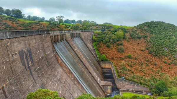
Meldon Dam, Okehampton Devon
There is a large car park at Meldon Dam, with toilets and a map of the area. A short walk south of the car park brings you to the impressive Meldon Dam constructed in 1972. I’ve been spoilt for choice lately with Dartmoor dams. They each have a certain attraction and charm, perhaps that’s the engineer in me looking at things.
As I walked across the dam, water and machinery could be heard rumbling away deep beneath the concrete superstructure. In a previous life I was fortunate to be able to work in a water treatment plant, so I have a good understanding of all that is hidden below.
Very much part of the attraction for me; what the eye doesn’t see, the mind starts to imagine.
The plan was to walk from Meldon Reservoir in an easterly direction up to Yes Tor, a location for years I had always wanted to visit. Either distracted by food, weather or the MOD firing guns! The military have been using Dartmoor for over 200 years and this walk is partly within a live firing range.
Before walking on the firing ranges you need to check online or by telephone for the published firing dates and on the day of your walk you should always check for red flags flying from the observation points along the marked range boundaries.
You shouldn’t let the limited public access put you off exploring safely this part of Dartmoor as it is very bleak and atmospheric, drama and remoteness but easily accessible by road.
Yes Tor – Dartmoor’s Second Highest Tor
I had always imagined the walk to Yes Tor would be a battle against the elements, a challenge of man verses mire; boots verses bog. The reality on this grey but dry day was a walk around the edge of Longstone Hill, take an obvious path due west of Yes Tor summit and walk eastwards up to the top and take a photo or three.
I apologise for the lack of drama in my opening words, the failing to enthuse. It really was that easy. Follow the track, pick my way around the granite boulders and arrive 619 metres above sea level. Made easy by the fact the reservoir car park is already some 330 metres ASL.
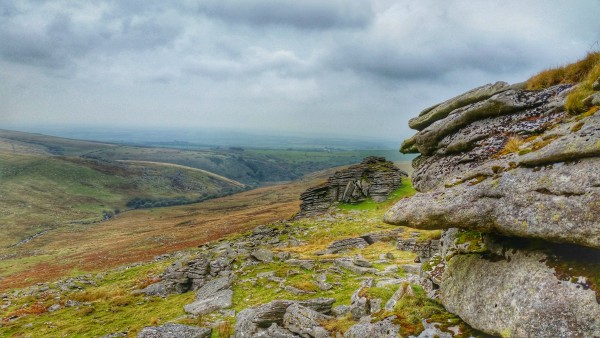
Now don’t imagine for one moment this would be an easy walk in thick mist, pouring rain, ice and hail. Dartmoor is bleak, unforgiving, stunningly beautiful and at the same time a cruel vicious landscape. Which is exactly why I love it. The sharpness of the fractured rocks, the twists and turns of every footstep, water running from every crevice. That brooding sky.
The approach to Yes Tor from the west is deceptive, you cannot see the trig point and radio aerial at all. You begin to question your judgement and route, if new to walking this area. Only when beyond the false summit (the cairn visible from the west) do you then see the trig point and radio mast. Ah, the penny drops, so this will be the summit then. A few hikers having a bite to eat out of the prevailing wind is normally a good clue too.
For those unsure as to the purpose of the humble trig point, these were constructed in the 1930s to help with the retriangulation of Great Britain. Triangulation is basically a mathematical process of measuring angles to other locations that makes accurate map making possible. 6500 trig points were constructed and many still survive today though modern technology has rendered them obsolete; just a folly now; a nod to the 1930’s map makers.
High Willhays – The Highest Dartmoor Tor
A short walk from Yes Tor, once considered the highest point on Dartmoor brings you to High Willhays. The undisputed highest point in Dartmoor and the South West. The difference in height between Yes Tor and High Willhays is a modest 2 metres, a little over 6 feet but if your quest is to walk to the highest point on Dartmoor then you need to go to the most southern of the tors at High Willhays, the OS Map shows which.
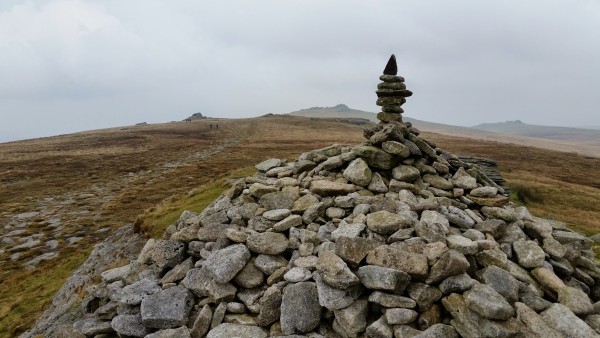
Place a stone, make a wish, nod hello.
One of the highlights of a landscape with an abundance of rock is the making of cairns, small monuments of stones, dedicated to long forgotten causes. High Willhays despite the howling wind was sporting a rather fine cairn.
I rearranged a few flat pieces of granite, added a couple of stones and stepped back carefully, having made this part of the moor a few artificially inches higher. I stopped for a bite to eat, taking shelter out of the wind for a few moments. Enough time to glance at the map and plot a compass bearing west towards Black Tor, overlooking West Okement River.
Black Tor – My Lunchtime Table Awaits
The weather wasn’t set to change any time soon, grey lead sky but no mist or rain forecast, so plenty of time to explore beyond High Willhays. I walked west to Black Tor, hoping to find a nice spot for lunch. Nothing too fancy, just a flat rock with a view.
Dropping down from the dizzy heights of High Willhays, a group of hikers could be spotted in the distance, making their own adventures, parallel to mine. We were all walking roughly the same route but no doubt with very different stories to tell over a cup of tea later.
Make your own adventures, create your memories today
Black Tor overlooks the West Okement River and this view offered peaceful shelter from the inquisitive autumnal wind, I remembered that same wind at Bignor and Chanctonbury Ring. Settling down on a flat slab of granite the wind died away to silence, no longer tugging at my collar. I had found the perfect spot to take in all that is Dartmoor once more.
Across the river valley, on Corn Ridge the sound of a voice could be heard, shouting loud and clear. Slowly and methodically sheep began to move from right to left, first just a few and then a few more, then perhaps twenty, now forty, must be a hundred. All following each other, like sheep do.
Dave my border collie sat still by my side, ears pricked upright in a state of alertness. His nose sniffed the calm air and his eyes scanned the distant valley slopes. He heard them too. A shepherd on a quad bike was commanding three sheepdogs. Tiny rapidly moving dots scoured the landscape in perfect harmony. The ultimate sheep driving machine.
Dave watched, knowingly. His instincts, his breeding told him this was something he could do, he understood this view. Unlike sunsets that don’t hold his attention for long, this working landscape captivated him whilst I watched and ate my humble lunch.
With the last of my lunch filling my belly and a healthy dose of wellbeing filling my soul it was time to head back towards Meldon Reservoir via a path along the banks of the West Okement River. This Dartmoor adventure was far from over, I had one more ace up my sleeve; the impressive, the immense, the towering Meldon Viaduct.
Meldon Viaduct – Engineering Triumph
With the exception of the tors, much of this walk is man-made. The reservoir once a natural now flooded valley and the awesome (yes I will use that word) viaduct is very much man-made over nature. I don’t think these intrusions detract from the beauty of the moors.
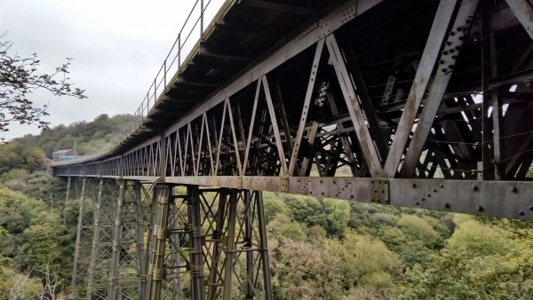
Now back at Meldon Dam, I followed a finger-post sign directing me north-east towards the viaduct. Photos cannot do the location justice. I had an idea what to expect but until I stood directly beneath the towering superstructure I really didn’t know just how awesome it would be.
You can safely say I was in awe
Curving gently across the valley and old mine workings, the Meldon Viaduct is a bold statement in an already striking landscape. Over 151 feet high in places and now part of the Granite Way, a recognised cycle route. The viaduct was opened in 1874 and is still standing proud in 2015.
Only two viaducts of this design remain in the UK and both are thankfully listed structures so hopefully we can enjoy them for many more years to come. Given the effort taken in construction it would be a dishonour to not protect them for future generations to stand beneath and look ever upwards.
Time was fading as it always does so I walked across the viaduct, wire mesh safety barriers prevent you from getting too close to the edge. I’m not afraid of heights so I did relish the occasional glimpse of the river some 150 feet below my boots, through gaps in the wooden decking.
I finished the walk off with a peer through the fencing at the gently decaying rolling-stock of theDartmoor Railway, their fully restored rolling-stock carries tourists and enthusiasts at certain times of the year over 15 miles of track.
From Meldon Viaduct I retraced my steps back towards the car park at the reservoir. I had seen the highest point on Dartmoor and had walked 151 feet above a river on a marvel of Victorian railway engineering. A very satisfying walk in my book.


